Advances in Retail GeoVisualization
By Dr. Tony Hernandez, Ming Du and Tahir Amin
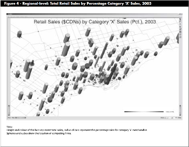
Geovisualization refers to the visual exploration, analysis , synthesis and presentation of geospatial data. This paper presents findings from research that has focused on developing and applying geovisualization techniques and technologies for use within retail location decision support. Retailers represent a major user group of Geographic Information System-based (GIS) decision support technologies, with applications ranging from trade area mapping to store portfolio planning. However, the ability to handle spatial-temporal data, visualize change, and explore the temporal dimension of spatial data is limited within conventional GIS. The paper details the development of a prototype geovisualization system that has been designed to enable visualization of spatial-temporal change of retail-related data. From the explicitly visual paradigm, a number of examples of potential analysis are examined at four different scales of analysis: national, regional, market and micro-level. The paper highlights both the challenges and potential to enhance retail decision support by integrating geovisualization techniques and technology within decision support activities